As I stated earlier in my post about Geographic Edutainment, I wanted to see whether the various geography and GIS folks on campus (geeks?) would enjoy coming together to view an ESRI Live Training Seminar together in a social environment.
Well, the first test was yesterday as I invited the campus community to attend a joint viewing of 'Spatial Statistics in ArcGIS 9'. More folks attended (and really enjoyed it) than I anticipated for this first test. With no more promotion than an email across the GIS@listserv.uta.edu listserv, eleven people attended, including faculty, students, and university staff. I was hoping for 3 to 5 people to attend, and wanted to grow this number as word of mouth spread.
I was blown away by how interested everyone was and how excited they were to meet eachother We had folks from real estate, geology, biology, urban planning, and mathematics, all sharing names and numbers with eachother and with me. Many of us stayed in the classroom for another 45 minutes discussing spatial statistics. It was fantastic.
Click here for a photo of 4 of us talking (after the seminar) about spatial statistics, ArcGIS extensions, GeoDa, and STARS. (I am in the blue shirt.) I have never used STARS (Space-Time Analysis of Regional Systems) before, but it is an "open source package designed for the analysis of areal data measured over time." Sounds great to me. I will play around with it the first chance I get.
What did I think of the seminar?? I was very, very impressed. The presenter and the woman answering the Q/A sessions (forgot both names, sorry) were both extremely good at taking complex and often inter-related issues and breaking them down nicely. Students attending who are new to GIS and/or statistics were able to follow along and understand easily. I especially liked their explanation and use of the z-score.
Friday, January 27, 2006


Tuesday, January 24, 2006
Great New Batch of Geography-Related Theses
There is a whole great new batch of geography/GIS-related Masters theses that have caught my eye.
Here are the prvious theses/dissertations posted: (Nov. 29, 2005) (Jan. 5, 2006)
A good way to keep up with the latest geography/GIS-related publications is to monitor GIS News: Publications.
Here are the prvious theses/dissertations posted: (Nov. 29, 2005) (Jan. 5, 2006)
A good way to keep up with the latest geography/GIS-related publications is to monitor GIS News: Publications.
- Geographic information system technologies as an educational tool in Ontario secondary schools
by Cameron, Tom, MEd, Queen's University at Kingston, 2005, 124 pages. - Development of a county level GIS program for risk assessment of West Nile Virus: The case of Gregg County Texas, 2003
by Brown, Johnny C., MIS, Stephen F. Austin State University, 2005, 72 pages. - Community mapping in Borneo: Issues of accuracy in traditional boundary delineation (Indonesia, Malaysia)
by Gibson, Lorraine Margaret, MA, Simon Fraser University, 2005, 124 pages. - Municipal geospatial information security
by Freeman, Christopher P., MA, The University of North Carolina at Greensboro, 2005, 49 pages. - The geography of juvenile crime place trajectories (Washington)
by Groff, Elizabeth Ruth, MA, University of Maryland, College Park, 2005, 116 pages. - Poverty, race and community organization: Social and environmental justice in Eugene, Oregon
by Pak, Maylian Joan, MA, University of Oregon, 2005, 129 pages. - The relationship between gambling and county-level crime
by Betsinger, Sara Linn, MA, University of Maryland, College Park, 2005, 89 pages. - The industrial transformation, Italian sex ratios, and the decline in fertility
by Skinner, Sarah, MA, University of Texas at Arlington, 2005, 54 pages.
Saturday, January 21, 2006
Three More Firefox GIS/Mapping Extensions
A few new mapping/GIS-related Firefox extensions have come out since I last posted about them. Here are the three new extensions:
- Map This
- Not as flexible as Map It! (my favorite mapping extension), but it will locate a selected address on Google or Yahoo! Maps.
- GeoLocateFox
- Originally blogged about by Spatially Adjusted
- This is a really cool extension. It will detect if you navigate to a webpage that supports GeoLocation (lat/long in meta tag), and show you the location of the webpage on a small Yahoo! Maps popup.
- Freeway Driving Directions
- A driving directions extension that requires users to configure home or starting addresses on their website. This bothers me. Especially with great extensions such as GDirections, which allows users to store multiple starting addresses much easier.
- Works with Expedia, MapQuest, and Yahoo! Maps.
Friday, January 20, 2006
ESRI Training Opportunities
Of course ArcGIS is far from free, but I really appreciate all of the training opportunities that are being made available. There are great ways that students (or any other ESRI user) can learn or increase their GIS skills.
So...No more excuses!! If you have access to ArcGIS and a desire to learn to use it, here are your free options:
This burst of aggression is actually my way of yelling at myself ;)
So...No more excuses!! If you have access to ArcGIS and a desire to learn to use it, here are your free options:
This burst of aggression is actually my way of yelling at myself ;)
- Live Training Seminars
- These are entirely free
- I especially appreciate the extensive archives
- Podcast Feeds
- The new service from ESRI is great for audio learners and folks who work at their desks and are tired of music and have already listened to this week's dose of AVSP.
- I hope these feeds are updated often.
- ESRI Virtual Campus: Free Training
- Many of these courses listed here have only a handful of free modules, but there are lots of free courses as well.
- ArcGIS Documentation (books)
- While these books are not freely available over the net to everyone, PDF versions are included with the ArcGIS 9 installation CDs.
- I mention these books because they are extremely useful. These are the books that I used when I first learned GIS (self-taught), and they are fantastic. I like the way each book starts out with an overview exercise that leads you through many of the simple and complex uses of the software and then subsequent chapters explain the procedures in more detail. I am a big fan.
Workshops: To Catch a Thief
As I previously stated, I am very excited about the workshops planned for this semester. Click here to see the official schedule, or here to see my original blog post describing the three workshops.
The workshop that I am most excited about is To Catch a Thief. Here are the details:
In addition, next Thursday we are sponsoring the first of our geographic edutainment events, an open showing of the ESRI Live Training Seminar, Understanding Spatial Statistics in ArcGIS 9. We'll see how many folks join us...
The workshop that I am most excited about is To Catch a Thief. Here are the details:
Title: To Catch a ThiefI will be releasing the clues simultaneously here as well. Should be lots of fun.
Time: Thursday, March 2, 3pm - 5pm
Location: Central Library, Room B-20
Description: Use state-of-the-art GIS (geographic information systems) to analyze crime patterns, predict potential targets, and try to track down the burglar. These fictitious burglaries all take place in Tarrant County, Texas. This is a hands-on demo with no GIS or criminal justice experience required.
Play to Win!
Each Friday during the month of February (Feb. 3, 10, 17, 24), we will be releasing evidence about these ongoing fictitious burglaries. The burglar might strike once or even twice during the week. Eye witnesses might report a seemingly irrelevant piece of information which might be critical. These clues will be released on flyers around campus, on the Libraries'’ website, and in on the University Calendar. If you can figure out the means of transportation taken by the burglar (how he is getting around) during the burglaries, email it to gislib@uta.edu. Faculty, students, or staff who send correct answers will be in a random drawing during the workshop, held on March 2. The deadline to guess is midnight (CST) on March 1. Winners will receive one free poster-sized print job by in the Library's Digital Media Studio.
In addition, next Thursday we are sponsoring the first of our geographic edutainment events, an open showing of the ESRI Live Training Seminar, Understanding Spatial Statistics in ArcGIS 9. We'll see how many folks join us...
Thursday, January 19, 2006
Position: Social Sciences Librarian. Swarthmore College
Social Sciences Librarian. Swarthmore College, Swarthmore, Pennsylvania
Granted, GIS is not in the title, but they do state "...working with the campus Information Technology Services department to support GIS applications for the college."
I like the sound of this position. Listen to this snippet: "...has responsibility for supporting government and nongovernmental data in multiple formats and for assisting users in the access, manipulation, and analysis of the data." Also, I have been to this part of Penn. before, right outside of Philly, and it is beautiful. They do not mention the salary.
Granted, GIS is not in the title, but they do state "...working with the campus Information Technology Services department to support GIS applications for the college."
I like the sound of this position. Listen to this snippet: "...has responsibility for supporting government and nongovernmental data in multiple formats and for assisting users in the access, manipulation, and analysis of the data." Also, I have been to this part of Penn. before, right outside of Philly, and it is beautiful. They do not mention the salary.
Yeay! - Paper Shipped Off
Here is the paper: PAPER
As I mentioned here, I am co-presenting a paper with a political science professor at the American Political Science Association Teaching and Learning Conference next month. Well, the deadline for presenters to submit the paper is tomorrow, so we are getting this in just under the wire.
Here is the abstract:
As I mentioned here, I am co-presenting a paper with a political science professor at the American Political Science Association Teaching and Learning Conference next month. Well, the deadline for presenters to submit the paper is tomorrow, so we are getting this in just under the wire.
Here is the abstract:
This paper demonstrates how the integration of quantitative datasets and Geographic Information Systems (GIS) into an undergraduate political science course increases studentsÂ’ familiarity with quantitative and geographic datasets while enhancing their understanding of the political science subject matter. At the University of Texas at Arlington, collaboration and planning between a political science faculty member and a GIS librarian enabled students in an undergraduate survey course to analyze when and where in the 254 Texas counties, Latino voters will constitute the majority of those eligible to vote and have the potential to win all local seats. Using demographic projections obtained from the Texas State Data Center and Office of the State Demographer and Census 2000 (SF3) data , students were able to examine the demographic patterns of the Latino voting eligible population in Texas counties through 2040 both in geographic and tabular format. They were also able to discover the tipping point in selected counties, where Latino voters would comprise the potential voting majority. When used as a classroom project by students they learn about Mexicans and other Latinos, U.S. Census data, population estimates, demographic projections, geography and history of Texas counties, push and pull factors of immigration and out migration, GIS mapping capabilities, and its use in other applications.
Sunday, January 08, 2006
ArcIMS Services Viewer: e-MapNet
e-MapNet is a freely available map viewer that supports ESRI's ArcIMS services. Created by e-Soft, an Italian company.
Came across this ArcIMS services viewer via comp.soft-sys.gis.esri.
It is a bit buggy, but it works as reported. It does not support WMS protocol, but the website states that this will be available in the next version. Another downside is that it is developed in .Net, and so will only work on Windows.
What I really do like about this little application is its size (546 kb unzipped) and that it runs without an installation requiring user permissions. At any time, students, professors, or even I can download this little app and run it from any of the computers on campus. For me, this makes it worth remembering.
Came across this ArcIMS services viewer via comp.soft-sys.gis.esri.
It is a bit buggy, but it works as reported. It does not support WMS protocol, but the website states that this will be available in the next version. Another downside is that it is developed in .Net, and so will only work on Windows.
What I really do like about this little application is its size (546 kb unzipped) and that it runs without an installation requiring user permissions. At any time, students, professors, or even I can download this little app and run it from any of the computers on campus. For me, this makes it worth remembering.
Saturday, January 07, 2006
Teaching an Intro to GIS Course: Focus on the Data
I want to take this moment to flesh out some ideas about how I feel an introduction to GIS course should be approached (by the teacher).
As I mentioned earlier I am teaching two courses this Spring semester. I am teaching (1) Understanding Geographic Information Systems (see syllabus), the first course in the Earth & Environmental Sciences SIS certification program, and (2) Advanced Real Estate Market Analysis, a graduate course that simultaneously introduces students to both the principles of market analysis research and GIS.
I have taught 3 graduate GIS-focused courses in the past and co-taught 1 more, so I am not coming at this with years of experience.
Nonetheless I have come to the conclusion that the crux of any intro to GIS course should be a heavy focus on the datasets and sources of data. This should include:
As I mentioned earlier I am teaching two courses this Spring semester. I am teaching (1) Understanding Geographic Information Systems (see syllabus), the first course in the Earth & Environmental Sciences SIS certification program, and (2) Advanced Real Estate Market Analysis, a graduate course that simultaneously introduces students to both the principles of market analysis research and GIS.
I have taught 3 graduate GIS-focused courses in the past and co-taught 1 more, so I am not coming at this with years of experience.
Nonetheless I have come to the conclusion that the crux of any intro to GIS course should be a heavy focus on the datasets and sources of data. This should include:
- finding/obtaining data
- evaluating data
- bringing together various datasets that perhaps were never originally intended to play nice
- This will provide students with the greatest flexibility to apply the GIS concepts that they learn in this course (and future GIS courses) in other subject areas. At this university, GIS is really taking off and students from various departments (see here) are flooding to all available GIS classes.
- I think in a very linear fashion, A-then-B-then-C-then-D-then... When I first learned GIS, I was relentlessly frustrated about not knowing where to get my hands on my own GIS data to duplicate the exercises in the textbook.
- It is empowering for students to confidently complete a GIS exercise entirely from scratch.
- Hey, I am a librarian, so I would naturally emphasize the data sources, right?
Why I Blog...
Vector One's (Jeff Thurston's) blog entry 'On Blogging' prompted me to set pen to paper (tips to keys) about how I would classify this blog and my reasons for blogging.
Looking through the five categories in the 'On Blogging' entry, this blog fits into number three, as the content here is almost entirely original. However, I am uncertain that the description provided ("Strives for original content, links to existing content in exceptional circumstances to support original content. Opinionated. Perceptive.") fits this blog as well as it fits Vector One. I think my blog also serves as a professional journal/diary of major activities that I am a part of. A running memoir?
That was easy, but why-o-why do I blog? This is a theme that has been thrown around quite a bit throughout the library blogosphere (for example). I enjoy blogging immensely, sure, but why?
[After some thought...] For me it must be the sense of self and purpose that is the greatest benefit of socializing...and of course this is what I am doing here. Sure I am quite shy and reserved in both the real world and the electronic, but writing this blog and reading countless other blogs is my way of communicating with all of you (and if you have actually read this far down, we sure are communicating, and how...). By shouting out all of my ideas right here on the public net, I feel validated. It is very satisfying. Each day I look forward to squeezing out some space in which I can sit and read some blogs and perhaps even write a blog entry myself.
Looking through the five categories in the 'On Blogging' entry, this blog fits into number three, as the content here is almost entirely original. However, I am uncertain that the description provided ("Strives for original content, links to existing content in exceptional circumstances to support original content. Opinionated. Perceptive.") fits this blog as well as it fits Vector One. I think my blog also serves as a professional journal/diary of major activities that I am a part of. A running memoir?
That was easy, but why-o-why do I blog? This is a theme that has been thrown around quite a bit throughout the library blogosphere (for example). I enjoy blogging immensely, sure, but why?
[After some thought...] For me it must be the sense of self and purpose that is the greatest benefit of socializing...and of course this is what I am doing here. Sure I am quite shy and reserved in both the real world and the electronic, but writing this blog and reading countless other blogs is my way of communicating with all of you (and if you have actually read this far down, we sure are communicating, and how...). By shouting out all of my ideas right here on the public net, I feel validated. It is very satisfying. Each day I look forward to squeezing out some space in which I can sit and read some blogs and perhaps even write a blog entry myself.
Thursday, January 05, 2006
2 Dissertations & 1 Scholarly Article
Continuing my previous post about theses and dissertations that caught my eye, here are 2 intriguing dissertations and an article that have...once again...caught my eye.
- Enhancing a domain-specific digital library with metadata based on hierarchical controlled vocabularies
by Weaver, Mathew Jon, Ph.D., OGI School of Science & Engineering, 2005, 123 pages - From the abstract: "We explain how Metadata++ integrates with a standard geographic information system to support both spatial and keyword-based information retrieval"
- I have ordered a copy of this dissertation.
- The American space of hunger: Geographic, political and economic change and the ability to eat in the United States in the late 1990s
by Walter, Nathan Andrew, Ph.D., The Florida State University, 2005, 363 pages - This dissertation discusses the "sphere of food security, a historically and geographically defined social space."
- Communities of Scholars: Places of Leverage in the History of Automated Cartography
by Chrisman, Nicholas R., Cartography and Geographic Information Science, vol. 32, iss. 4, pp. 425-433(9) - From the abstract: "This paper will describe the community into which automated cartography emerged...It makes sense to remember a bit more about the pre-history of geographic information systems, not just to get the history right, but to understand how the events of prior periods influence the way the technology develops."
Social Events: Free Geographic Edutainment
I enjoy free GIS seminars, such as the ESRI Live Training Seminars, and podcasts such as Very Spatial and Where It's At.... I suppose there must be other folks (other geeks?) on campus here at UT Arlington who do or would enjoy this as well.
So, I figure let's all hang out and enjoy these snippets of free geographic edutainment together...right?
Well, I am starting off with the next ESRI Live Training Seminar, which is focused on spatial statistics. This is perfect as the number of folks from a variety of disciplines on campus needing to test/adjust for spatial autocorrelation is growing every semester.
I reserved one of the classrooms in the library with 27 PCs, all loaded with ArcGIS 9 and two mounted projectors. This way the screens can display the video and the room's speakers can pump out the audio, while everyone can either follow along on their own PCs (muted) or even play around with the concepts during the seminar.
I think this should be a lot of fun and hopefully this will help to bring the diverse GIS-dabbling folks on campus together. And if it's just me...well, hey I'll have the best seat in the house.
Should this be successful, I want to test this out with the Very Spatial podcast. Of course there is no video, but if there is something else going on at the same time, such as a geography game/contest, food, or something, perhaps it will be more enjoyable than just sitting and listening. Pizza, beer, and GIS...lovely isn't it??
So, I figure let's all hang out and enjoy these snippets of free geographic edutainment together...right?
Well, I am starting off with the next ESRI Live Training Seminar, which is focused on spatial statistics. This is perfect as the number of folks from a variety of disciplines on campus needing to test/adjust for spatial autocorrelation is growing every semester.
I reserved one of the classrooms in the library with 27 PCs, all loaded with ArcGIS 9 and two mounted projectors. This way the screens can display the video and the room's speakers can pump out the audio, while everyone can either follow along on their own PCs (muted) or even play around with the concepts during the seminar.
I think this should be a lot of fun and hopefully this will help to bring the diverse GIS-dabbling folks on campus together. And if it's just me...well, hey I'll have the best seat in the house.
Should this be successful, I want to test this out with the Very Spatial podcast. Of course there is no video, but if there is something else going on at the same time, such as a geography game/contest, food, or something, perhaps it will be more enjoyable than just sitting and listening. Pizza, beer, and GIS...lovely isn't it??
Wednesday, January 04, 2006
Paleomap Project & Geoprocessing Script
Been super-busy and so have not posted in quite some time. There are a number of things that have been occupying my time, but let's start with the Python script that I have been developing.
The Paleomap Project, developed by Dr. Chris Scotese, is designed to display the evolving Earth as tectonic plates have shifted through time. This project is recognized worldwide as a resource for students and teachers of Earth history. A nice overview can be found here. (Oh, and did you catch the reference to Chris and his work on Very Spatial Episode 21?)
Well, I have been helping him to integrate the Plate Tracker program that Chris wrote in VB6 into ArcMap. Put quite a bit of effort into this, but as always with such efforts, I sure learned a lot. The program allows users to view how different polygons on the Earth's surface would look in a given time period of Earth's history (measured in millions of years).
I will not post the code, but here is the logic of the script:
Works like a charm. The two biggest hurdles that I had to overcome were (1) handling multipart and donut (inner circles) polygons, and (2) Ensuring that the resulting polygon contained the same attributes as the original file. Solving these hurdles taught me a lot about lists and sublists in Python. Special thanks to all the folks over at ArcView-L for helping me out with the donut polygon problems. This is a great listserv where folks will definitely get back to you.
The Paleomap Project, developed by Dr. Chris Scotese, is designed to display the evolving Earth as tectonic plates have shifted through time. This project is recognized worldwide as a resource for students and teachers of Earth history. A nice overview can be found here. (Oh, and did you catch the reference to Chris and his work on Very Spatial Episode 21?)
Well, I have been helping him to integrate the Plate Tracker program that Chris wrote in VB6 into ArcMap. Put quite a bit of effort into this, but as always with such efforts, I sure learned a lot. The program allows users to view how different polygons on the Earth's surface would look in a given time period of Earth's history (measured in millions of years).
I will not post the code, but here is the logic of the script:
- Convert polygon to table of XY coords
- Launch Plate Tracker (VB6 executable) which shifts the coords according to the time period selected
- Python once again takes over and converts the shifted coords into a new polygon feature class
Works like a charm. The two biggest hurdles that I had to overcome were (1) handling multipart and donut (inner circles) polygons, and (2) Ensuring that the resulting polygon contained the same attributes as the original file. Solving these hurdles taught me a lot about lists and sublists in Python. Special thanks to all the folks over at ArcView-L for helping me out with the donut polygon problems. This is a great listserv where folks will definitely get back to you.
Tuesday, December 20, 2005
Holiday Facts & Figures From the US Census Bureau
Let’s throw a little bit of Census data into the bonfire of holiday spirit. Here is a list of resources provided by the U.S. Census Bureau about the current holiday season.
via: GISuser.com
20.8 million Christmas trees were cut in 2002. Yes, 20.8 Million. Now, c'mon folks...let's all buy plastic trees, OK?
via: GISuser.com
20.8 million Christmas trees were cut in 2002. Yes, 20.8 Million. Now, c'mon folks...let's all buy plastic trees, OK?
Position: GIS Specialist (Purdue University Libraries)
Geographical Information Systems (GIS) Specialist. Purdue University Libraries, West Lafayette, Indiana.
Was on vacation last week and I am happy to be back online and posting yet another GIS library position. The more positions out there the healthier the industry (the GIS Librarian industry, that is...).
Well, this position is really knocking my socks off. The section under 'Responsibilities' lists it all, but the primary responsiblity sums it nicely:
Was on vacation last week and I am happy to be back online and posting yet another GIS library position. The more positions out there the healthier the industry (the GIS Librarian industry, that is...).
Well, this position is really knocking my socks off. The section under 'Responsibilities' lists it all, but the primary responsiblity sums it nicely:
"Primary responsibility will be to develop and implement the library’s GIS program."Definitely one to take a look (or two) at...
Monday, December 12, 2005
Position: Digital Spatial Data/Digital Collections Librarian
Digital Spatial Data/Digital Collections Librarian - UWM Libraries - AGS Library
via: Maps-L
Deadline to apply for this exciting-sounding librarian position at the American Geographical Society Library is this Friday.
According to the job advertisement, this position will work on "archiving and maintaining of digital spatial data clearinghouse materials." Now, don't forget that this is the American Geographical Society Library...Very intriguing to say the least.
Oh, and here are some pictures of the AGS Library.
via: Maps-L
Deadline to apply for this exciting-sounding librarian position at the American Geographical Society Library is this Friday.
According to the job advertisement, this position will work on "archiving and maintaining of digital spatial data clearinghouse materials." Now, don't forget that this is the American Geographical Society Library...Very intriguing to say the least.
Oh, and here are some pictures of the AGS Library.
Saturday, December 10, 2005
Mapping Tools for Firefox
All sorts of folks (including us GIS/mapping folks) use the Mozilla Firefox web browser. Here are a list of GIS/mapping-related extensions, plugins, and other resources available for Firefox.
- Mapdex Search Plugin
- This search plugin was recently developed and announced by Jeremy at the Mapdex Blog.
- I have been testing it out the last couple of days and it works great. Search across "A global index of 1,805 servers, serving 32,612 map services, containing over 400,000 GIS Layers, covering more than 4,000,000 columns!" Great stuff.
- MapIt!
- This extension, developed by Jason Heddings, has been my favorite mapping/driving directions extension for a while now.
- Selected text can be mapped using any of the following web maps: GlobeXplorer, Google Maps, MapQuest, MapsOnUs, TerraServer, and Yahoo! (the old Yahoo! Map).
- Driving directions can also be generated as MapIt! allows users to store one home address.
- For those of you who upgraded Firefox to 1.5, you can still install this (and other) older extension by following these simple instructions.
- GDirections
- This extension, developed by Jeffrey Palm, finds driving "directions on Google Maps based on your selected text and one of various home addresses."
- The key feature for this extension is the ability to store and manage numerous home addresses.
- The MutantMaps Firefox Toolbar
- Initially announced here, this toolbar allows "navigation between all of the popular mapping sites while preserving your longitude, latitude and zoom levels." Google Maps, MSN Virtual Earth, MultiMap, TerraServer and 192.com are supported.
- There is even word that this toolbar will preserve user locations on the mashups as well.
- Greasemonkey
- Versatile extension allowing users to manipulate web pages using "user scripts".
- Here are the mapping Greasemonkey user scripts that I am aware of:
- MyLocations for Google Maps
- Gmap Extras!
- HOW-TO: Make your own annotated multimedia Google map (engadget)
- UPS Package Tracking with Google Maps
- Greasemap
- Monkeying with Planet Geospatial (import cartography)
* Script allows users to control the feeds visible on the Planet Geospatial site. This is a great script...just don't filter the librarian... - Streetmap
- Developed by Dave Nolan, this extension provides a "simple UK streetmap search from context menu."
- Select Search
- This extension, developed by Girish Gangadharan, is not primarily a mapping extension, but it does include an advanced context menu category called 'Map it' which currently includes Google Maps and Yahoo! Maps. He is also a friend of mine, so I really want to let folks know about his new extension.
Position: NOAA Librarian
Librarian, ZA-1410-03 (DEU/MAP) - Commerce, National Oceanic and Atmospheric Administration - Montgomery, MD
This position is located in NOAA National Environmental Satellite, Data and Information Service (NESDIS), National Oceanic Data Center, Library and Information Services Division, Contract Operations. The incumbent will serves as a special format librarian, for photo library request, cataloging and maintenance of electronic resources, maps, computer files and videos.If the personality of a workplace is evident from the job posting, then this should be a fun place to work. I love how they specify...
You don't need to be a rocket scientist to work here. You can be a business manager, engineer, meteorologist, physical scientist, information technologist, international affairs specialist, or, even a rocket scientist.
Thursday, December 08, 2005
So, Who Uses Spatial Technologies?
Well, I sure can't answer that question conclusively. I do, however, count the number of students who come in to the GIS Lab needing assistance. These students will be the professionals of tomorrow, and I like to think of these numbers as a small microcosm of current and future spatial technology use.
Here is a breakdown of the 474 students who came into the GIS Lab needing help this Fall 2005 semester
click to enlarge
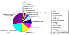
As you can see, we do not have a geography department at the university, so approximately 1/2 of folks needing spatial assistance are either in Earth & Environmental Sciences or Urban & Public Administration. This makes sense as these are the only two departments that confer degrees and certifications in GIS/RS.
It is the other 1/2 that interest me the most. With only a handful of actual credit courses in their major departments, these students are often going out of their way to include maps and spatial analysis in their projects. An ambitious professor who pushes him/herself and their students is always a great motivator.
There are three things that really stand out in my mind from this semester.
Here is a breakdown of the 474 students who came into the GIS Lab needing help this Fall 2005 semester
click to enlarge

As you can see, we do not have a geography department at the university, so approximately 1/2 of folks needing spatial assistance are either in Earth & Environmental Sciences or Urban & Public Administration. This makes sense as these are the only two departments that confer degrees and certifications in GIS/RS.
It is the other 1/2 that interest me the most. With only a handful of actual credit courses in their major departments, these students are often going out of their way to include maps and spatial analysis in their projects. An ambitious professor who pushes him/herself and their students is always a great motivator.
There are three things that really stand out in my mind from this semester.
- First are all of the marketing students who are taking it on themselves to use spatial datasets and analysis. Once one student found out the great marketing/consumer datasets that we have, these marketing students never stopped coming. Combined, the marketing and real estate students took up almost 18% of my student assistance hours this semester. Let's hear it for the ambitious business students.
(Especially as I get ready to teach the Advanced Real Estate Market Analysis course next semester.) - Second of all was that super-ambitious anthropology student needing to perform a batch viewshed analysis of stone circles in Ireland. This was a lot of fun to assist the student with and it gave GIS a lot of exposure in the anthropology department. The work I did with this student lead to all of the geoprocessing demonstrations and applications I developed this semester.
- Third of all is that the variety of students and question types continue to increase each semester. Political Science students seeking looking to map voting potential. History students seeking to map population and boundary shifts. Add in there epidemiological studies, community assessments for need-based grants, spatial based property valuations...the list really goes on and on.
The Frost and Sullivan report, announced by All Points Blog, project increases in the use and development of location based services. There is no doubt that these students will be the consumers and developers.
Wednesday, December 07, 2005
Canadian Electoral District Maps
The 2004 Federal Electoral District Maps (Canada) are available for free download from Geogratis.
Via: University of Saskatchewan Library: Data Library News Blog
Of course this is part of that great Geogratis site that I wish I knew about when I was working in Buffalo, NY. Anyone needing good national-level spatial datasets for Canada can find loads of good stuff at the Geogratis site.
Check out their Data Archive....
Via: University of Saskatchewan Library: Data Library News Blog
Of course this is part of that great Geogratis site that I wish I knew about when I was working in Buffalo, NY. Anyone needing good national-level spatial datasets for Canada can find loads of good stuff at the Geogratis site.
Check out their Data Archive....
Tuesday, December 06, 2005
Followup: Latest Issue of The Cartographic Journal
This is a follow up from this post.
Turns out that the focus of the December 2005 issue of The Cartographic Journal...
Turns out that the focus of the December 2005 issue of The Cartographic Journal...
"is the special issue from the CUAC/LC conference on the Future of Map Libraries at the Library of Congress in May. It includes all (or essentially all) of the talks given at that conference."
Sent from anonymous poster on Maps-L.
The GIS Feed Community
Keeping current with the latest happenings and events in the GIS world has become very daunting.
The 'GIS Feed Community' is growing very quickly. There are just so many blogs entries, news items, discussions, and technology releases that are really, really interesting and fun stuff that I do not want to miss a moment of them.
So here is an overview of current resources as I understand them. This can serve as an introduction to the somewhat daunting task of keeping up with the GIS feed community, and especially good for folks (like students) first starting to venture out there...
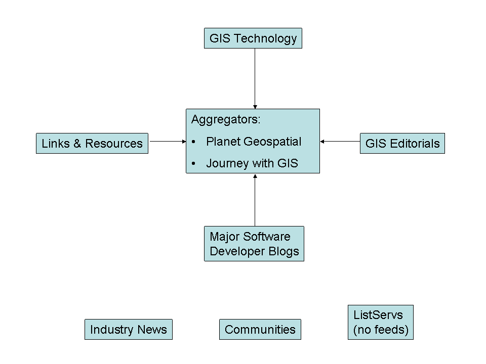
The diagram below represents the sectors of the GIS feed community (Click to Enlarge)
The 'GIS Feed Community' is growing very quickly. There are just so many blogs entries, news items, discussions, and technology releases that are really, really interesting and fun stuff that I do not want to miss a moment of them.
So here is an overview of current resources as I understand them. This can serve as an introduction to the somewhat daunting task of keeping up with the GIS feed community, and especially good for folks (like students) first starting to venture out there...
The diagram below represents the sectors of the GIS feed community (Click to Enlarge)
- Aggregators
- Aggregators pull the latest feeds from a variety of sources and display them on one page. They have been very useful in giving the spatial community a central gathering place.
- There are three key aggregators, Planet Geospatial, Journey with GIS, and Planet GIS. Planet Geospatial is especially useful as James Fee does a fantastic job maintaining the aggregator and selecting sites for inclusion, as well as providing access to the XML feed and OPML.
- GIS Editorials
- These are blogs that comment upon, or editorialize on the state of the spatial industry or of particular aspects. They give us the big picture of things.
- Examples include Vector One, EdParsons.com, and think.
- GIS Technology
- These are blogs that focus on GIS technology (in general). They are written/maintained by GIS users and developers and comprise the bulk of the GIS feed community.
- Click here for a list of these GIS Technology blogs.
- Links & Resources
- These are resources that primarily point to and often times compare various resources on the web.
- Key examples include Cartography, The Map Room, and Google Maps Mania.
- Major Software Developer Blogs
- These are blogs maintained by employees of major GIS software developer companies.
- I have no idea whether ESRI is promoting this or not, but ESRI employees have really taken an interest in blogging. The entire list can be viewed here. Chandu Thota's WebLog is a good blog coming from a MapPoint developer.
- Industry News
- There are numerous happenings and releases within the GIS industry these days. It is possible to receive all the important news by using the resources listed above, but if you want to ensure that nothing slips through your grasp you can get your news directly.
- Click here to access a list of industry news feeds.
- Communities
- Communities (user forums) are bulletin boards where you can send/answer questions and discuss GIS topics.
- A list of communities can be found here. Some key communities include SlashGISRS, CartoTalk, comp.infosystems.gis, and comp.soft-sys.gis.esri.
- ListServs with No Feeds
- Unfortunately not all resources currently provide feeds and we are forced to monitor them via email.
- ListServs that I monitor include ESRI-L/ArcView-L, Maps-L, and MapHist.
- Podcasts
- I forgot to include this sector in the image above, but podcasts are downloadable mp3 files that serve as GIS radio shows.
- You must, must, must listen to A VerySpatial Podcast. It is great. Another new podcast whose first episode was very good is Where It's At....
- Directory of GIS Feed Community
- A directory containing these and other categories of available GIS-related feeds can be found here.
- And please oh please do not forget about us librarians. :)
- Other Topics of Interest
- In addition to those mentioned here, other topics of interest for the GIS feed community include: Employment, Scholarly Publications, and Web Mapping.
Saturday, December 03, 2005
Latest Issue of The Cartographic Journal: Maps/GIS & Libraries
The latest issue (December 2005) of the The Cartographic Journal is dedicated entirely to mapping and geospatial issues in libraries. I have not yet been able to get my hands on an issue as our library has not yet received the print copy (any day now...) and our electronic access via Academic Search Premier has not yet updated their content to include this latest issue.
Click here to view the table of contents.
I will post about these articles in more detail once I can actually read them.
Of course, you too can keep up with the latest scholarly GIS publications here.
Click here to view the table of contents.
I will post about these articles in more detail once I can actually read them.
Of course, you too can keep up with the latest scholarly GIS publications here.
Friday, December 02, 2005
GIS Workshops: Spring 2006
I am really, really excited about the workshops we have lined up for next (Spring 2006) semester. Here are the three workshops that we have in mind:
- Murder Mystery (See this earlier post)
- Of course this is a play on the hit TV show Numb3rs.
- I am planning a workshop early March 2006, in which I will lead all workshop participants through an exercise where we use GIS and spatial technologies to track down the cause of a series of fictitious mysterious deaths in Fort Worth.
Here is how I plan to set this up. In mid to late January, I want to announce this event. Announcing the event will involve laying out some basic facts about the fictitious deaths. Then, I want to release more facts and maps of the area pinpointing locations each Wednesday during the month of February. Each week during the month of February, any UTA person may email their solution to the crime. Then, during the first week of March, anyone who has been following the mystery can come to the Library for a hands-on analysis of the fictitious crime details using GIS software to search for patterns using complex mathematical algorithms, thereby solving the crime. The person who solved the crime correctly during the month of February will win something, but of course only if they attend the workshop. (A possible solution that I have been tossing around is following the bus lines, but I do not think I will settle on something so simple.)
I want to release these facts in the campus newspaper various Library publications. I think that I can get the campus newspaper to go along with this, as long as we have an enticing idea, which I believe this to be. - ArcGIS & the Google Maps API
- I plan on holding this in early April 2006. This workshop will be designed for ArcGIS users to learn how to use Google Maps as the front-end for their GIS applications. This is what we did for the Friday Night Hangout project.
- I plan on demonstrating how to download the API and how to export various feature classes into an XML format fit for Google Maps.
- Where to Open a New Pizzeria in the DFW Metroplex?
- This will be held between the Google Maps workshop and the end of the semester.
- This is one of the most popular workshop that I have held and repeat it at least once a year. More than any other, I receive requests from faculty to hold this exercise specifically for their classes. The exercise uses the ArcMap ModelBuilder to provide a form-driven suitability analysis. This is already complete, and you can download the exercise, complete with step-by-step instruction and intro power point here.
Thursday, December 01, 2005
Free Blogging Tools
There are some great free blogging tools out there.
The Geographic Information Systems (GIS) GeoBlog inspired me and I have added the following resources to my blog:(These tools can be found on the bottom right-side of my blog)
I also discovered, for those of you hosting your blog on Blogspot (like me), a free TrackBack pinger: Trackback wizard. I have not tried HaloScan yet, but I hear this free resource can give Blogger blogs the ability to store TrackBacks.
The Geographic Information Systems (GIS) GeoBlog inspired me and I have added the following resources to my blog:(These tools can be found on the bottom right-side of my blog)
I also discovered, for those of you hosting your blog on Blogspot (like me), a free TrackBack pinger: Trackback wizard. I have not tried HaloScan yet, but I hear this free resource can give Blogger blogs the ability to store TrackBacks.
Wednesday, November 30, 2005
Raster Surfaces for Hurricanes Katrina & Rita
The Center for International Earth Science Information Network's (CIESIN) Socioeconomic Data and Applications Center (SEDAC) has created downloadable raster surfaces compiled from U.S. Census 2000 SF1 and SF3 datasets. Download the data here: http://beta.sedac.ciesin.columbia.edu/katrina2005.html.
Via: COMPASS: GIS@libraries.gmu.edu
This is a welcome resource as the most popular student GIS projects this semester is analyzing the affects of the hurricane season.
Via: COMPASS: GIS@libraries.gmu.edu
This is a welcome resource as the most popular student GIS projects this semester is analyzing the affects of the hurricane season.
Position: Research Program Specialist II (GIS) (Sacramento, CA)
RESEARCH PROGRAM SPECIALIST II (GIS) at California Department of Transportation (Sacramento, CA)
This position sounds like a nice balance between the acquisition/organization of spatial data and complex analysis.
From the position description: "The incumbent will conduct independent complex research projects involving analysis and make recommendation as to how the spatial data library can best serve users of transportation data." The possible salary range extends into the $70,000 range, but this could be the cost of living in Sacramento.
This position sounds like a nice balance between the acquisition/organization of spatial data and complex analysis.
From the position description: "The incumbent will conduct independent complex research projects involving analysis and make recommendation as to how the spatial data library can best serve users of transportation data." The possible salary range extends into the $70,000 range, but this could be the cost of living in Sacramento.
Tuesday, November 29, 2005
Firefox Extension: Search Select
A friend of mine just wrote his first Firefox extension, Select Search 1.0. This extension will run selected text through a variety of searches.
He included in the Advanced context menu a category called Map it which currently included Google Maps and Yahoo! Maps. I am pushing him to also include some others (Virtual Earth among others) in later releases.
Check it out if you have a moment.
He included in the Advanced context menu a category called Map it which currently included Google Maps and Yahoo! Maps. I am pushing him to also include some others (Virtual Earth among others) in later releases.
Check it out if you have a moment.
Coordinates (ALA MAGERT) Journal Indexed
The Directory of Open Access Journals recently began indexing Coordinates : Online Journal of the Map and Geography Round Table of the American Library Association.
This indexing is down to the article level. Link directly to the Series A and Series B records.
Via: Maps-L
This indexing is down to the article level. Link directly to the Series A and Series B records.
Via: Maps-L
Caught My Eye: Recent GIS Theses/Dissertations
There has been a load of new theses/dissertations released, and of course I am able to keep up with them using the GIS News: Publications feed aggregator.
Here are some of the published theses/dissertations that have caught my eye:
Here are some of the published theses/dissertations that have caught my eye:
- A GIS model for predicting potential "high risk" areas of West Nile virus by identifying ideal mosquito breeding habitats [ PDF Text ]
by Wallis, Robert Charles, M.S., Mississippi State University, 2005, 118 pages - Essays on neighborhood effects and spatial diffusion: Evidence from online grocery retailing
by Song, Sangyoung, Ph.D., University of Pennsylvania, 2005, 146 pages - The choreography of community: Italian ethnicity in postwar Toronto and Philadelphia
by Stanger-Ross, Jordan, Ph.D., University of Pennsylvania, 2005, 221 pages - A spatial analysis of disaggregated commuting data: Implications for excess commuting, jobs-housing balance, and accessibility
by Lee, Wook, Ph.D., The Ohio State University, 2005 - Characterizing differences between categorical maps as functions of composition and configuration: A hierarchical spectra approach
by Remmel, Tarmo Kaarel, Ph.D., University of Toronto, 2005 - Evaluating input data for DEM-based environmental analysis and classification
by Deng, Yongxin, Ph.D., University of Southern California, 2005 - Geopolitical analysis of terror in selected United States media sources
by Goodman, Aaron, M.A., Marshall University, 2005, 35 pages
Sunday, November 27, 2005
Personal Data Privacy And Security Act of 2005
Now my emotions and my rationale are torn between having access to great marketing and real estate data on the one hand, and the fear of an invasion into my (and others) personal life on the other. If I could wave my magic wand and have instant access to household-level credit card expenditures, my initial response would be excitement and a desire to see how different expenditures were distributed. (If you follow this blog, please do not be turned off by this.) It would not be until a few heartbeats later that I would question whether I had the right to investigate this data.
The Personal Data Privacy And Security Act of 2005 (PDF full-text of S. 1789) was just approved by the Senate Judiciary Committee and moves forward to Senate hearings. This brings the issue to the forefront for me.
Via: beSpacific
Of interest to me is 'Title II - Data Brokers', beginning on page 15. Here is a snippet that I found interesting.
Also of interest is 'Title III - Privacy and Security of Personally Identifiable Information', beginning on page 25. This states that the individual protections provided under this Title are only enforceable if a business maintains personal information on at least 10,000 Americans. This seems to be a large loophole as smaller communities can be left unprotected.
'Title IV - Government Access to and Use of Commercial Data' (p. 54) stipulates (gosh, these words just seem to come out of nowhere when writing about legal matters) that federal agencies may acquire personal data from a data broker if the agency: (1) completes a privacy impact statement, and (2) adopt regulations that specify how the data will be handled. It will be interesting to see whether we (the public) may access these statements and regulations.
The Personal Data Privacy And Security Act of 2005 (PDF full-text of S. 1789) was just approved by the Senate Judiciary Committee and moves forward to Senate hearings. This brings the issue to the forefront for me.
Via: beSpacific
Of interest to me is 'Title II - Data Brokers', beginning on page 15. Here is a snippet that I found interesting.
"A data broker shall, upon request of an individual, disclose to such individual for a reasonable fee all personal electronic records pertaining to that individual..."So, I will have to pay a reasonable (??) fee to find out what information companies have about me?
Also of interest is 'Title III - Privacy and Security of Personally Identifiable Information', beginning on page 25. This states that the individual protections provided under this Title are only enforceable if a business maintains personal information on at least 10,000 Americans. This seems to be a large loophole as smaller communities can be left unprotected.
'Title IV - Government Access to and Use of Commercial Data' (p. 54) stipulates (gosh, these words just seem to come out of nowhere when writing about legal matters) that federal agencies may acquire personal data from a data broker if the agency: (1) completes a privacy impact statement, and (2) adopt regulations that specify how the data will be handled. It will be interesting to see whether we (the public) may access these statements and regulations.
Saturday, November 26, 2005
Free EBSCO Search: GIS Resources
EBSCO Publishing now provides free access to LISTA (Library, Information Science & Technology Abstracts) at this URL: http://www.libraryresearch.com.
Via: The Distant Librarian
This is great for the library world, and is equally as great for the GIS-focused library world as we all now have free access to all GIS-related articles published in LISTA indexed journals. Here is a static link to a search for GIS within this free EBSCO database.
I received an email last week announcing EBSCO's intention to provide RSS feeds for all of its databases, and when this happens I will add GIS-related feeds to the 'GIS News: Publications' feed aggregator.
Via: The Distant Librarian
This is great for the library world, and is equally as great for the GIS-focused library world as we all now have free access to all GIS-related articles published in LISTA indexed journals. Here is a static link to a search for GIS within this free EBSCO database.
I received an email last week announcing EBSCO's intention to provide RSS feeds for all of its databases, and when this happens I will add GIS-related feeds to the 'GIS News: Publications' feed aggregator.
Essential Software in a GIS Lab
Here is my list of essential software for an academic GIS Lab.
If anyone would suggest other applications/scripts or an entirely new category, please either leave a comment or email me at been AT uta DOT edu. Please note that there are only PCs available. Obviously, this very closely resembles the relevant applications on my PC.
I am preparing this list because I share our student's frustration at not having access to all of these resources in one lab. Students often have to run between different labs to access the software they need. The following list is NOT currently the configuration of any of the GIS Labs on campus.
If anyone would suggest other applications/scripts or an entirely new category, please either leave a comment or email me at been AT uta DOT edu. Please note that there are only PCs available. Obviously, this very closely resembles the relevant applications on my PC.
I am preparing this list because I share our student's frustration at not having access to all of these resources in one lab. Students often have to run between different labs to access the software they need. The following list is NOT currently the configuration of any of the GIS Labs on campus.
- Spatial Applications
- 3D Mapping Systems
- ArcGIS Extensions & Scripts
- TerraServer Download for ArcGIS 9.0 (Version2)
- XT Download SRTM File
- Hawth's Analysis Tools for ArcGIS 9
- Geoprocessing Wizard Toolbar
- ET GeoWizards LT
- ArcMap MXD to ArcIMS AXL converter/ export utility
- MapView SVG 4 Professional
- Programming
- Statistical Software
- Graphics
- Databases
- See Spatially Adjusted for a discussion about favorite ArcGIS extensions and scripts.
Position: GIS Librarian (Virginia - Herndon)
GIS Librarian (Virginia - Herndon)
This position is with a private company, and is looking for an entry-level person who will be "scanning maps, georeferencing, image manipulation, metadata capture and editing in support of map library."
The only reference that I have yet found regarding this position is this link from an employment agency.
This position is with a private company, and is looking for an entry-level person who will be "scanning maps, georeferencing, image manipulation, metadata capture and editing in support of map library."
The only reference that I have yet found regarding this position is this link from an employment agency.
Wednesday, November 23, 2005
Photo: Special Operations Forces: Traverse through Military Terrain
Photo
Photo of student working through the Special Operations Forces: Traverse through Military Terrain yesterday. The workshop went off without a hitch, which is rare, but it defenitely helped that I just guided a Geosciences class through this exercise last week.
If you have ArcGIS 9.x with Spatial Analyst, you can work through the exercise as well. Just download the files, extract the files to the 'C:\' drive, and launch the MXD. There is a Word document that will provide step-by-step directions.
Very soon, I will have to post about planned workshops for next semester.
Photo of student working through the Special Operations Forces: Traverse through Military Terrain yesterday. The workshop went off without a hitch, which is rare, but it defenitely helped that I just guided a Geosciences class through this exercise last week.
If you have ArcGIS 9.x with Spatial Analyst, you can work through the exercise as well. Just download the files, extract the files to the 'C:\' drive, and launch the MXD. There is a Word document that will provide step-by-step directions.
Very soon, I will have to post about planned workshops for next semester.
Tuesday, November 22, 2005
GIS Day/Tech Fair 2005 Review
Click here for photo.
Well, the GIS Day 2005 / Techfair festivities last Wednesday worked out great.
The Friday Night Hangout has proven to be as successful as I had hoped. (Of course you can still participate to see where you should hang out this Friday night here.) The success of this project is its ability to continue to get folks excited about GIS even 1 week after the event. I am still getting emails from students and faculty telling me that they just added themselves to the map after hearing about it from a friend or colleague.
This is the first web-based geoprocessing application that I ever developed, and after this response there is no doubt that I will develop more. Especially now that I am bit further up that learning curve. The possibilities become almost limitless. I can now take many of the workshops that I have created and create web applications. The military path workshop that I am holding this afternoon? No problem. I can use a similar ASP form, and the results can be displayed in either ArcIMS or Google Maps again. I have the blueprints in my mind for a short script that can export a polyline directly from a feature class to a Google Maps polyline. I think developing at least one more web-based geoprocessing application will be my big project for Summer 2006...I can't wait for summer to get here fast enough.
In the photo (I finally signed up for a Flickr account) Heather, a student assistant who works with me, is guiding a fellow student through the Friday Night Hangout form. Heather is the best. Isn't the poster too cool? Ms. Candy has such a way with fun designs.
Well, the GIS Day 2005 / Techfair festivities last Wednesday worked out great.
The Friday Night Hangout has proven to be as successful as I had hoped. (Of course you can still participate to see where you should hang out this Friday night here.) The success of this project is its ability to continue to get folks excited about GIS even 1 week after the event. I am still getting emails from students and faculty telling me that they just added themselves to the map after hearing about it from a friend or colleague.
This is the first web-based geoprocessing application that I ever developed, and after this response there is no doubt that I will develop more. Especially now that I am bit further up that learning curve. The possibilities become almost limitless. I can now take many of the workshops that I have created and create web applications. The military path workshop that I am holding this afternoon? No problem. I can use a similar ASP form, and the results can be displayed in either ArcIMS or Google Maps again. I have the blueprints in my mind for a short script that can export a polyline directly from a feature class to a Google Maps polyline. I think developing at least one more web-based geoprocessing application will be my big project for Summer 2006...I can't wait for summer to get here fast enough.
In the photo (I finally signed up for a Flickr account) Heather, a student assistant who works with me, is guiding a fellow student through the Friday Night Hangout form. Heather is the best. Isn't the poster too cool? Ms. Candy has such a way with fun designs.
Reference Librarian/Environmental & Geosciences Liaison
Western Carolina University - Hunter Library: Reference Librarian/Environmental & Geosciences Liaison
This is the first exciting GIS Librarian position that I have come across in some time (as opposed the this repeater).
I like the fact that they are asking for experience with government documents and the small student body of under 9,000 will give this position (in my opinion) a great deal of influence concerning mapping & GIS in the library and the university.
This is the first exciting GIS Librarian position that I have come across in some time (as opposed the this repeater).
I like the fact that they are asking for experience with government documents and the small student body of under 9,000 will give this position (in my opinion) a great deal of influence concerning mapping & GIS in the library and the university.
Sunday, November 20, 2005
Lots o' Data/GIS Library Blogs
OK, there are indeed some other GIS and Data blogs out there. Earlier today, when I posted that I only knew of three, this was true at the time. However, due to the popularity of the GIS Librarians Frappr map many new blogs have come my way and these have all been added to the 'GIS News: Library Blogs' page.
Here are all of the GIS blogs that I am currently at this moment aware of:
Here are all of the GIS blogs that I am currently at this moment aware of:
- Compass-Point News @ UBLib
- COMPASS: GIS@libraries.gmu.edu
- Data Interest Group for Reference Services
- Data Library News Blog
- GIS At Brown
Not really a library-based blog, but it seemed to fit here nonetheless - KSL New Books in GIS
This is empty at this moment, but hopefully it will not always be - Maps/GIS - Government Information and Maps - Georgia State University
- mapz: a gis librarian
- MIT Libraries News: GIS
UB Geosciences Blog: Resources & Publications
Michele Shular, Geosciences Librarian at the University of Buffalo (my alma mater), maintains a blog entitled Compass-Point News @ UBLib. The description is:
Excluding my blog, this makes the second GIS-related blog coming out of a library that I have yet found. The other is COMPASS: GIS@libraries.gmu.edu out of the Government Documents and Maps department of Fenwick Library. I originally posted about this blog here. Should I rethink the name of my blog to include the word 'compass' in it? Well, I reckon the purpose is quite different.
These three library-based blogs (including my own) can be found at the 'GIS News: Library Blogs' page (updated every hour).
A navigation through geographic resources at UB Libraries, pointing you in the right direction.Michele does a good job posting about new GIS-related publications for the UB community, and I for one will also be monitoring the blog to keep myself up to date as well.
Excluding my blog, this makes the second GIS-related blog coming out of a library that I have yet found. The other is COMPASS: GIS@libraries.gmu.edu out of the Government Documents and Maps department of Fenwick Library. I originally posted about this blog here. Should I rethink the name of my blog to include the word 'compass' in it? Well, I reckon the purpose is quite different.
These three library-based blogs (including my own) can be found at the 'GIS News: Library Blogs' page (updated every hour).
Saturday, November 19, 2005
Course: Advanced Real Estate Market Analysis
Next Spring 2006 semester, I am teaching Advanced Real Estate Market Analysis, a graduate course for the Department of Finance & Real Estate. I also taught this course last spring, but I plan to do things a bit differently this time around. So as usual, I am fleshing my thoughts out here...
Last spring, I divided the course into four quarters. During the first quarter, we focused on market analysis principles and appropriate sources of data. During the second quarter, the students built geodatabases (personal) using the data sources learned during the first quarter, and performed a suitability analysis for the retail sector in the DFW metroplex. The third quarter focused on property valuations mainly using spatial regression analysis. The fourth quarter focused on freely available web mapping options, including SVG and Flash. I taught this course at a very fast pace and the last quarter also gave the students time to reflect and digest.
The course last spring was very successful, but I would like to implement more of a case study approach. The required textbook this semester is "Real Estate Market Analysis: A Case Study Approach." Instead of clearly delineating the semester into 4 parts, I want to focus more on the textbook. There are 7 chapters in the book, 2 introducing market analysis and 5 on specific market sectors. If I spend 2 weeks on each chapter, the students can interpolate scenarios from the case studies to hypothetical scenarios here in the DFW metroplex. Weekly projects will then be turned in based on local data they collected and spatial analysis they performed. In other words (I am thinking aloud here...) the course will be structured a bit more thematically.
Good, I am pleased with this.
This makes the course a bit more of a challenge to organize as I now have to gradually build upon the basic GIS and spatial analysis techniques as the course progresses. This must happen simultaneously with the progression through the case studies in the book. So that the students can implement the spatial analysis necessary toward the middle/end of the semester, they first must learn the enough of the basics of GIS during the first parts of the course.
It should be a good semester. The Environmental and Earth Science department has recently expressed an interest in me teaching a GIS course for them this spring semester as well. It would be great if I teach that course too. If I do teach this additional course, the two possibilities would be either Geographic Data Analysis or Understanding Geographic Information Systems. Either course would be a pure GIScience course, and so I would be able to focus completely on what is truly my passion...GIS.
Here is a list of other graduate courses that I have previously taught:
Last spring, I divided the course into four quarters. During the first quarter, we focused on market analysis principles and appropriate sources of data. During the second quarter, the students built geodatabases (personal) using the data sources learned during the first quarter, and performed a suitability analysis for the retail sector in the DFW metroplex. The third quarter focused on property valuations mainly using spatial regression analysis. The fourth quarter focused on freely available web mapping options, including SVG and Flash. I taught this course at a very fast pace and the last quarter also gave the students time to reflect and digest.
The course last spring was very successful, but I would like to implement more of a case study approach. The required textbook this semester is "Real Estate Market Analysis: A Case Study Approach." Instead of clearly delineating the semester into 4 parts, I want to focus more on the textbook. There are 7 chapters in the book, 2 introducing market analysis and 5 on specific market sectors. If I spend 2 weeks on each chapter, the students can interpolate scenarios from the case studies to hypothetical scenarios here in the DFW metroplex. Weekly projects will then be turned in based on local data they collected and spatial analysis they performed. In other words (I am thinking aloud here...) the course will be structured a bit more thematically.
Good, I am pleased with this.
This makes the course a bit more of a challenge to organize as I now have to gradually build upon the basic GIS and spatial analysis techniques as the course progresses. This must happen simultaneously with the progression through the case studies in the book. So that the students can implement the spatial analysis necessary toward the middle/end of the semester, they first must learn the enough of the basics of GIS during the first parts of the course.
It should be a good semester. The Environmental and Earth Science department has recently expressed an interest in me teaching a GIS course for them this spring semester as well. It would be great if I teach that course too. If I do teach this additional course, the two possibilities would be either Geographic Data Analysis or Understanding Geographic Information Systems. Either course would be a pure GIScience course, and so I would be able to focus completely on what is truly my passion...GIS.
Here is a list of other graduate courses that I have previously taught:
- Advanced Topics in Sociology
- Texas A&M International University
- Advanced Topics in Marketing Research
- University of Texas at Arlington
- Understanding Geographic Information Systems
- University of Texas at Arlington
Friday, November 18, 2005
Frappr: GIS Librarians
I have just created a new Frappr map, called GIS Librarians to help to tie the two ends of my blogoshpere together.
To all of us who provide GIS/spatial services in a library setting, add youself to this Frappr map so we can see who and of course where we all are.
To all of us who provide GIS/spatial services in a library setting, add youself to this Frappr map so we can see who and of course where we all are.
Thursday, November 17, 2005
Polygon 2 XY Table 2 Polygon
Some folks here need to create a automated task that can easily convert polygon vertices to a table containing XY coords. They would like to be able to edit this table using their homemade algorithms and then recreate the polygon based on the moved XY coords.
I was concerned that the capabilities of the ESRI geoprocessing objects that I have been infatuated with over the past year or so might have reached their limit and that I would have to undust my crusty old ArcObject tombs. However, ESRI did not let me down. Right there on pages 66-70 of Writing Geoprocessing Scripts (PDF book bundled with the ArcGIS package) and also in the ArcGIS Desktop Help, it describes the geometry object which can be accessed with the SearchCursor, InsertCursor, and the UpdateCursor. There is even an example of reading coords from a text file and creating a polyline. Wonderful!
Well, I am using the IGPDispatch to create the COM connection using .NET, and everything is going smoothly so far given this great documentation provided in the Writing Geoprocessing Scripts e-book. I will post the file here as soon as I have finished it.
I was concerned that the capabilities of the ESRI geoprocessing objects that I have been infatuated with over the past year or so might have reached their limit and that I would have to undust my crusty old ArcObject tombs. However, ESRI did not let me down. Right there on pages 66-70 of Writing Geoprocessing Scripts (PDF book bundled with the ArcGIS package) and also in the ArcGIS Desktop Help, it describes the geometry object which can be accessed with the SearchCursor, InsertCursor, and the UpdateCursor. There is even an example of reading coords from a text file and creating a polyline. Wonderful!
Well, I am using the IGPDispatch to create the COM connection using .NET, and everything is going smoothly so far given this great documentation provided in the Writing Geoprocessing Scripts e-book. I will post the file here as soon as I have finished it.
Tuesday, November 15, 2005
Hate Crime Statistics, 2004
The 2004 edition of the FBI publication, Hate Crime Statistics was recently released.
via: BeSpacific
All of the data tables are available for direct download in Excel format, and many of the variables are provided on the state and city level.
From the site:
via: BeSpacific
All of the data tables are available for direct download in Excel format, and many of the variables are provided on the state and city level.
From the site:
"Hate Crime Statistics, 2004 , chronicles 7,649 criminal incidents that law enforcement agencies reported--as motivated by a bias against a race, religion, disability, ethnicity, or sexual orientation--and includes information on 9,035 offenses, 9,528 victims, and 7,145 known offenders. Eleven of the 14 tables in this publication present various information about hate crime incidents, the types of offenses committed, and some aspects of the victims and the offenders. The remaining tables contain hate crime data aggregated by state or agency type and show the parameters of participation for law enforcement agencies that contributed data to the program."
Sunday, November 13, 2005
Least Cost Path Analysis Through Military Terrain
Tuesday evening (yes, the day before the Tech Fair), I am meeting with a geoscience class to guide them through a workshop that I devised 2 years ago. The workshop is entitled 'Shortest Path Analysis Through Military Terrain'. However, I believe that ESRI changed their function from shortest path to least cost path, so I might have to update the name accordingly. I have not glanced or even thought about this exercise in at least a year, and so this blog entry is my attempt to jog my memory.
So, here is the scenario envisioned during the workshop. Texas is under seige, of course from an unidentified/unmentioned enemy. It is our job to take out/destroy certain key facilities in areas currently under the control of the enemy. So, we gather base data including DEM elevation data and certain TIGER files (roads, railways, urban areas, hydrology). Then we gather current intelligence including the locations of the key enemy facility in this quad, enemy mine fields, and the locations of enemy troops.
Then, of course, we plan the optimal path from a randomly generated starting point to the enemy facility. The shortest (least cost) path function is used with various rules defining the cost of traversing through any peice of terrain.
I actually have not experimented with the differences between running this exercise on ArcGIS 8.3 and 9.0, so I forsee where my free time will be spent tomorrow... The old versions (designed for ArcGIS 8.3) of this exercise can be found here: (Workshop without data provided | Workshop with data provided).
So, here is the scenario envisioned during the workshop. Texas is under seige, of course from an unidentified/unmentioned enemy. It is our job to take out/destroy certain key facilities in areas currently under the control of the enemy. So, we gather base data including DEM elevation data and certain TIGER files (roads, railways, urban areas, hydrology). Then we gather current intelligence including the locations of the key enemy facility in this quad, enemy mine fields, and the locations of enemy troops.
Then, of course, we plan the optimal path from a randomly generated starting point to the enemy facility. The shortest (least cost) path function is used with various rules defining the cost of traversing through any peice of terrain.
I actually have not experimented with the differences between running this exercise on ArcGIS 8.3 and 9.0, so I forsee where my free time will be spent tomorrow... The old versions (designed for ArcGIS 8.3) of this exercise can be found here: (Workshop without data provided | Workshop with data provided).
EPA TRI Data Availability
The U.S. EPA might scale back its Toxic Release Inventory (TRI) Program, a common data source for environmental mapping.
via: FCW.COM
Full Text of TRI forms Modification Rule: 39931 Federal Register / Vol. 70, No. 132, Tuesday, July 12, 2005
Here are two key snippets from the TRI Reporting Forms Modification Rule (Final) FAQ:
via: FCW.COM
Full Text of TRI forms Modification Rule: 39931 Federal Register / Vol. 70, No. 132, Tuesday, July 12, 2005
Here are two key snippets from the TRI Reporting Forms Modification Rule (Final) FAQ:
- "This final rule eliminates certain information from the TRI reports, simplifies other reporting elements..."
- "EPA will no longer require TRI facilities to report locational information (latitude and longitude data) and several facility identifiers (regulatory assigned identification codes for each facility). Instead, the data will be obtained from existing EPA databases and made available to TRI data users."
Saturday, November 12, 2005
Google Maps EZ New Forums & Feed
Google Maps EZ has recently created an RSS Feed, and a new Usenet group, called Google Maps EZ has also been created.
Google Maps EZ provides public access to their javascript codes to greatly ease the use of the Google Maps API. I rely very heavily on Google Maps EZ for the Friday Night geoprocessing project.
Google Maps EZ provides public access to their javascript codes to greatly ease the use of the Google Maps API. I rely very heavily on Google Maps EZ for the Friday Night geoprocessing project.
Friday Night Hangout Follow Up
Aside from adding some images and perhaps tinkering with the colors a bit, this fully online application is complete.
Here is the URL: http://gis.uta.edu/fridaynight
Here is the description of the application (copied verbatim from the site):
This site was developed by the UTA Libraries: GIS Program to demonstrate the capabilities of geographic information systems, the Google Maps API, and the power of combining the two.
After filling out this short online form, a geoprocessor (.NET application accessing ESRI geoprocessing objects) is launched which computes a simple suitability analysis to derive the best location that is most suitable based on the user selections. All user results are stored in the database, so the number of locations and the number of people hanging out at these locations will continue to increase. Expand the All the UTA Party People menu (below) to see a list of the people who are currently hanging out.
So, just sit and think for a moment. How can a suitability analysis such as this be used in your studies? Your work? Your life? The UTA Libraries: GIS Program is available to help all UTA students, faculty, and staff to perform spatial analysis, locate spatial datasets, automate spatial tasks, and general GIS assistance. We can even assist with the creation and maintenance of online mapping services, such as the Google Maps API.
Here is the URL: http://gis.uta.edu/fridaynight
Here is the description of the application (copied verbatim from the site):
This site was developed by the UTA Libraries: GIS Program to demonstrate the capabilities of geographic information systems, the Google Maps API, and the power of combining the two.
After filling out this short online form, a geoprocessor (.NET application accessing ESRI geoprocessing objects) is launched which computes a simple suitability analysis to derive the best location that is most suitable based on the user selections. All user results are stored in the database, so the number of locations and the number of people hanging out at these locations will continue to increase. Expand the All the UTA Party People menu (below) to see a list of the people who are currently hanging out.
So, just sit and think for a moment. How can a suitability analysis such as this be used in your studies? Your work? Your life? The UTA Libraries: GIS Program is available to help all UTA students, faculty, and staff to perform spatial analysis, locate spatial datasets, automate spatial tasks, and general GIS assistance. We can even assist with the creation and maintenance of online mapping services, such as the Google Maps API.
Thursday, November 10, 2005
Geography-Related Dissertation Feeds Now Available
Another scholarly publication vendor now provides public RSS feeds. Proquest now provides RSS feeds for its dissertation database. The feed directory can be found here.
via: The Distant Librarian
I have added 4 dissertation topic feeds (below) to the GIS News: Publications category. This link will take you to the most current GIS-related articles aggregated from the IngentaConnect feeds and now the most current GIS-related dissertations from the Proquest feeds.
The 4 Geography-Related Dissertation Feeds:
ProQuest: Dissertations - Environment Geography
ProQuest: Dissertations - Environment Geophysics
ProQuest: Dissertations - Engineering Civil
ProQuest: Dissertations - Sociology Demographics
via: The Distant Librarian
I have added 4 dissertation topic feeds (below) to the GIS News: Publications category. This link will take you to the most current GIS-related articles aggregated from the IngentaConnect feeds and now the most current GIS-related dissertations from the Proquest feeds.
The 4 Geography-Related Dissertation Feeds:
ProQuest: Dissertations - Environment Geography
ProQuest: Dissertations - Environment Geophysics
ProQuest: Dissertations - Engineering Civil
ProQuest: Dissertations - Sociology Demographics
New USGS Blog: Topo Employees
Topo Employees
via: The Map Room
"Rumors, rants, and a little actual information about happenings in the USGS national mapping program."Some folks at the USGS "unoficially" created this blog last month as a direct reaction to the decision to abandon and the subsequent decision not to abandon the USGS Center at Rolla.
via: The Map Room
Wednesday, November 09, 2005
Caught Between 2 Blogospheres
My position as an GIS Librarian forces me to do some juggling. My colleagues in the library are all professional librarians or support staff, but I also consider many of the GIS-focused faculty as colleagues as well. So, in essence, I am being pulled by two spheres.
This is perfectly represented as I am caught between two Frappr-driven blogospheres:
At this moment, there are 14 librarian bloggers registered and 8 GIS bloggers registered. I try to keep up with most interesting blogs out there, so go ahead and register yourselves. Perhaps there might even be other cross-overs out there as well. The only other GIS/Library blog that I am aware of is out of George Mason University Libraries.
This is perfectly represented as I am caught between two Frappr-driven blogospheres:
At this moment, there are 14 librarian bloggers registered and 8 GIS bloggers registered. I try to keep up with most interesting blogs out there, so go ahead and register yourselves. Perhaps there might even be other cross-overs out there as well. The only other GIS/Library blog that I am aware of is out of George Mason University Libraries.
GIS Day, Tech Fair, & Hanging Out on Friday Nights
While I have not seen a lot of buzz this year surrounding 'GIS Day', next Wednesday is indeed the day. Like the previous three years, GIS Day activities on campus are overpowered by the UTA Tech Fair. This year, the Tech Fair is exactly on November 16. So, all of us departments that are demonstrating GIS technologies during the fair (library, geosciences, & urban planning) are going to have our own corner with a banner announcing GIS Day.
Well, our booth (library GIS booth) will showcase our Friday Night Hangout application. This entirely web-based application performs a basic suitability analysis (based on reclassifying layers and calculating the weighted average) that calculates the ideal location in Tarrant County, TX, where they should hang out on Friday Night. Users fill out a quick form online, the suitability analysis is performed, and their location is showed via Google Maps API. The best part is that it records everyone's results in the geodatabase, and so it shows you where everyone else is hanging out and if you anyone else will be hanging out in the same establishment as the user. I think it is pretty cool and I hope that it will serve as a good hook to pull folks into thinking about mapping in a new and fun way.
So, this project has been revamped and improved upon since I first developed it earlier in the semester for the Library Technology Round-Up. There are two big changes.
Well, our booth (library GIS booth) will showcase our Friday Night Hangout application. This entirely web-based application performs a basic suitability analysis (based on reclassifying layers and calculating the weighted average) that calculates the ideal location in Tarrant County, TX, where they should hang out on Friday Night. Users fill out a quick form online, the suitability analysis is performed, and their location is showed via Google Maps API. The best part is that it records everyone's results in the geodatabase, and so it shows you where everyone else is hanging out and if you anyone else will be hanging out in the same establishment as the user. I think it is pretty cool and I hope that it will serve as a good hook to pull folks into thinking about mapping in a new and fun way.
So, this project has been revamped and improved upon since I first developed it earlier in the semester for the Library Technology Round-Up. There are two big changes.
- The original Python geoprocessing script has been replaced with .NET. This has done wonders as I am much more comfortable programming in .NET than Python, and am much more comfortable working with geoprocessing functions than ArcObjects. Once I found the appropriate article on the ESRI Knowledge Base, HowTo: Use IGPDispatch in .NET, I was all set. The working code can be viewed here. This is the first .NET application that primarily used the IGPDispatch connection as opposed to the more traditional ArcObjects and this is opening up whole new worlds for me.
- The application is entirely web-based now. Originally, there was a .NET windows form that passed parameters to the Python script using the Shell() command. Now, the ASP calls the .NET geoprocessing code (discussed above) and everything is so much more robust.
Sunday, November 06, 2005
'GIS News' Enhancements
We have created two features which will enhance the 'GIS News' feed aggregator site.
1. There is now a default feed that appears when the page is first loaded called 'GIS News - Librarian's Picks'. This feed will consist entirely of hand-selected entries by the GIS Librarian (me) as a way to help the GIS community here at UT Arlington sift through the ever-growing number of GIS news resources on the Net.
2. The problem with the pages taking too long to load has been resolved by replacing all pictures and multimedia linked from the individual feeds with a small png image that simply reads 'IMAGE'. Everything should be much faster now.
1. There is now a default feed that appears when the page is first loaded called 'GIS News - Librarian's Picks'. This feed will consist entirely of hand-selected entries by the GIS Librarian (me) as a way to help the GIS community here at UT Arlington sift through the ever-growing number of GIS news resources on the Net.
2. The problem with the pages taking too long to load has been resolved by replacing all pictures and multimedia linked from the individual feeds with a small png image that simply reads 'IMAGE'. Everything should be much faster now.
Let's Map Ourselves: Where Are We Again?
Mateusz Loskot recently set up a 'GIS Bloggers Map' using Frappr.com, a Google Maps API interface similar to CommunityWalk.
I have added myself and would love to see all the GIS and map-loving bloggers out there on this Frappr map. As of this very moment, Mateusz, James Fee, and myself are the only ones on there. Oh, wait a sec, I also see a test user...that also happens to be Mateusz.
Via: comp.infosystems.gis .
Also mentioned on mateusz.loskot.net and Very Spatial.
I have added myself and would love to see all the GIS and map-loving bloggers out there on this Frappr map. As of this very moment, Mateusz, James Fee, and myself are the only ones on there. Oh, wait a sec, I also see a test user...that also happens to be Mateusz.
Via: comp.infosystems.gis .
Also mentioned on mateusz.loskot.net and Very Spatial.
Saturday, November 05, 2005
GIS Librarian Job (yes, this one again...)
Geodata Librarian - SRA - Langley, VA
It has been quite a while since I have been able to post about a new GIS Librarian position. In fact, there are quite a number of parallels between this new job posting and the previous one.
Let's take a look:
Latest Job Post: November 5, 2005
Last Job Post: August 28, 2005
Latest Job Title: Geodata Librarian - SRA - Langley, VA
Last Job Title: Geodata Librarian: SRA International, Inc. (Mclean, VA)
Oh, and you might just want to throw this one in there for good measure: July 23, 2005
So, is SRA an employment agency, or is there just an incredible amount of turn-over? Or perhaps they employ an army of GIS Librarians in their attempt to catalog the spatial universe...
It has been quite a while since I have been able to post about a new GIS Librarian position. In fact, there are quite a number of parallels between this new job posting and the previous one.
Let's take a look:
Latest Job Post: November 5, 2005
Last Job Post: August 28, 2005
Latest Job Title: Geodata Librarian - SRA - Langley, VA
Last Job Title: Geodata Librarian: SRA International, Inc. (Mclean, VA)
Oh, and you might just want to throw this one in there for good measure: July 23, 2005
So, is SRA an employment agency, or is there just an incredible amount of turn-over? Or perhaps they employ an army of GIS Librarians in their attempt to catalog the spatial universe...
Thursday, November 03, 2005
American Housing Survey - 2004 Select Cities
The U.S. Census just released the 2004 data from the American Housing Survey.
The AHS is released each year for select cities. This year the Texas city is San Antonio.
Provides data on housing and household characteristics from the American Housing Survey. Data is presents on the total housing inventory including new construction and vacant units; on total occupied housing units; on owner-occupied housing units; on renter-occupied housing units; on occupied housing units with a Black householder, and on occupied housing units with householder of Hispanic origin.
In addition, the report covers such subjects as: data on external building conditions; number of rooms; complete bathrooms; kitchen and laundry equipment; main heating equipment; fuel used for heating, cooking, and central air-conditioning; plumbing equipment and failures; and opinions of the structure and neighborhood.
The AHS is released each year for select cities. This year the Texas city is San Antonio.
Wednesday, November 02, 2005
How to Get Jim, George, and Sally Their Spatial Data
OK, so as I discussed here, we have devised three ways to access spatial data that we are collecting in the library. This has been a constant struggle as our 25,000 strong student body makes it impossible to secure site licensing.
Our ace in the hole has been Citrix (Previous Post | Website), but some vendors (this one and this one) have been giving us a bit of a hard time. One of these vendors is holding us up right now as our users cannot access the data because we are negotiating the license to allow us distribute the data via Citrix.
So, let's follow Jim, George, and Sally as they try to access data from our library's Geospatial Catalog (GeoSpat).
As you will see, Sally exhibits the response that I am struggling to minimize. If you have any ideas, please post them here or let me know (gislib AT uta DOT edu).
I cannot control how Sally reacts to this situation, but this reaction occurs quite a bit. I can, however, work to minimize the situations that prompt Sally to come to her terrible decision.
So, we are still looking into other ways to distribute our data, but I do not think that we will ever totally overcome that dreaded license issue. My goodness, it is hard work not to break license agreements. (But it would be my job if I ever did.)
One of the products we are looking into is the ArcIMS Data Delivery Extension. This seems really, really cool. I have not run into a single website that is actually using it, but we installed it on our server and I am looking forward to playing around with it over the winter holidays.
Our ace in the hole has been Citrix (Previous Post | Website), but some vendors (this one and this one) have been giving us a bit of a hard time. One of these vendors is holding us up right now as our users cannot access the data because we are negotiating the license to allow us distribute the data via Citrix.
So, let's follow Jim, George, and Sally as they try to access data from our library's Geospatial Catalog (GeoSpat).
As you will see, Sally exhibits the response that I am struggling to minimize. If you have any ideas, please post them here or let me know (gislib AT uta DOT edu).
- Jim searches GeoSpat looking for geologic data for Webb County, Texas.
Comes up with a hit. Great. The data is being served by Citrix. Let me give that a shot.
Drat. Computer telling him that the maximum numbers of users (1) are currently using the application and that he should try again in a few minutes.
OK, waiting now...Try again. Yep, this time it works. Downloading the data. Wow, there is even a tutorial that some lovely librarian must have created. :)
- George searches GeoSpat for FEMA flood data in Tarrant County, Texas.
Holey-mackeral...GeoSpat leads George to the direct download site (UTA Only).
Click it, download it, unzip it, view it. Hey, this even has good metadata. Cool.
- Sally is looking for landuse data for Asia.
Sally searches GeoSpat.
Got a hit . Fantastic.
Let's see here...where is the download button? Says here that I need to go to the Reference Desk?!?!?!? All the way at the Central Library!
Well, shiver my timbers...That's way across campus. Forget it then. I didn't need that data anyway.
I cannot control how Sally reacts to this situation, but this reaction occurs quite a bit. I can, however, work to minimize the situations that prompt Sally to come to her terrible decision.
So, we are still looking into other ways to distribute our data, but I do not think that we will ever totally overcome that dreaded license issue. My goodness, it is hard work not to break license agreements. (But it would be my job if I ever did.)
One of the products we are looking into is the ArcIMS Data Delivery Extension. This seems really, really cool. I have not run into a single website that is actually using it, but we installed it on our server and I am looking forward to playing around with it over the winter holidays.
GIS News: Feed Aggregator
The University of Texas at Arlington Libraries is pleased to announce a new web application that the Libraries have developed, called 'GIS News'. The purpose of this application is to enable the GIS community here at UTA to easily access up-to-the-hour news and events in the GIS world at large.
'GIS News' currently aggregates over 100 XML feeds (RSS and Atom) and sorts them into 14 categories. The content is updated every 60 minutes.
Here are some quick examples of the uses of this web application:
1. Most current GIS-related job opportunities:
http://library.uta.edu/gis/gisNews.jsp?cat=Employment
2. Most recently published articles in GIS-related jouornals:
http://library.uta.edu/gis/gisNews.jsp?cat=Publications
3. Most recent postings on various GIS-related public user forums:
http://library.uta.edu/gis/gisNews.jsp?cat=Forums
4. Most current GIS-related news and press releases:
http://library.uta.edu/gis/gisNews.jsp?cat=Industry%20News
_______________________
Yes, I know this in many ways duplicates Planet Geospatial, but as I stated here, "...this [must be] a great-minds-think-alike moment."
'GIS News' currently aggregates over 100 XML feeds (RSS and Atom) and sorts them into 14 categories. The content is updated every 60 minutes.
Here are some quick examples of the uses of this web application:
1. Most current GIS-related job opportunities:
http://library.uta.edu/gis/gisNews.jsp?cat=Employment
2. Most recently published articles in GIS-related jouornals:
http://library.uta.edu/gis/gisNews.jsp?cat=Publications
3. Most recent postings on various GIS-related public user forums:
http://library.uta.edu/gis/gisNews.jsp?cat=Forums
4. Most current GIS-related news and press releases:
http://library.uta.edu/gis/gisNews.jsp?cat=Industry%20News
_______________________
Yes, I know this in many ways duplicates Planet Geospatial, but as I stated here, "...this [must be] a great-minds-think-alike moment."
ESRI Free Training: Explores Basics of the Geodatabase Data Model
Free, Live Training Seminar Explores Basics of the Geodatabase Data Model
I ranked an understanding of relational databases as number 5 of the Top 10 Most Common Student-Encountered GIS Problems, so students who use ArcGIS should definitely check this out.
I ranked an understanding of relational databases as number 5 of the Top 10 Most Common Student-Encountered GIS Problems, so students who use ArcGIS should definitely check this out.
Tuesday, November 01, 2005
Harry Potter GIS Workshop & Thoughts...
( - formatting fixed - )
In a couple of days, I am holding the following workshop: Magic Compass Spells: U.S. Branch of the Hogwarts School of Witchcraft & Wizardry -- Where Should it Be? (Information | Download Materials). I first held this particular workshop over the summer when the last HP book came out, and then I repeated it when Junior High students came to visit the library. Well, third time is coming up.The workshop has been successful in attracting lots of folks to participate in this simple spatial analysis exercise who might never have been exposed to GIS beyond online mapping.It really got me thinking about why…
Situation:
Our Information Services (Reference) librarians have scaled our Library’s Open Demo program down to, well pretty much down to nothing. An open demo is where we pick a particular research tool or topic and announce an open demonstration at a particular time, promote it, and hope for the best as far as a showing.Well, we have not had much of a showing at all which led to the temporary suspension of the open demo program. From what I have seen in the other two libraries that I have worked in, this situation is not unique to us.Now, on the other hand I still hold 3-4 open demos, which I style as workshops, every semester and am always pleased with the attendance and more importantly is that many of these people return during my office hours with follow-up questions.
Question:
Why? What is the difference between my workshops and the other library open demos? Is GIS just so exciting that it sells itself?
Answer:
I actually touched upon this a bit during a presentation I made last summer at the Texas Library Association annual conference, entitled ‘Hands-On GIS Demos: It’s Easy to get People Excited’. But I want to use this space to elaborate in a bit more detail.The answer is in the relevancy of the demonstration. In our information saturated society, students with a computer, access to their library’s wealth of databases, and a little determination can track down most of the data/information that they need.Students need, or perhaps even crave, to know how to apply the data/information to solve practical problems. The absolute worst philosophy is that academic library resources are here to help with your classes.
Examples of Bad Demos:
If I were to hold a workshop entitled: Learn What GIS Can Do for You, or GIS and the Census 2000, or even worse GIS for Your Papers: It’s Easy!, I would anticipate very few attendees. Along these same lines, a library open demo entitled: Learn to Search the Library Catalog, or Learn to Find Book Reviews will also have a tough time exciting the students.
Examples of Good Demos:
So, let’s turn back to Harry Potter. How about an open demo entitled: Harry Potter: What the Critics are Saying to show students how traditional print and electronic indexes can complement the reviews they read on Amazon. The students can even be shown how the library catalog can be searched for monograph reviews. Or how about demos entitled: Post-911 Terrorism Bills: Find out How Your Representatives Voted, or Be Prepared for You Job Interview: Local Company Research...
In a couple of days, I am holding the following workshop: Magic Compass Spells: U.S. Branch of the Hogwarts School of Witchcraft & Wizardry -- Where Should it Be? (Information | Download Materials). I first held this particular workshop over the summer when the last HP book came out, and then I repeated it when Junior High students came to visit the library. Well, third time is coming up.The workshop has been successful in attracting lots of folks to participate in this simple spatial analysis exercise who might never have been exposed to GIS beyond online mapping.It really got me thinking about why…
Situation:
Our Information Services (Reference) librarians have scaled our Library’s Open Demo program down to, well pretty much down to nothing. An open demo is where we pick a particular research tool or topic and announce an open demonstration at a particular time, promote it, and hope for the best as far as a showing.Well, we have not had much of a showing at all which led to the temporary suspension of the open demo program. From what I have seen in the other two libraries that I have worked in, this situation is not unique to us.Now, on the other hand I still hold 3-4 open demos, which I style as workshops, every semester and am always pleased with the attendance and more importantly is that many of these people return during my office hours with follow-up questions.
Question:
Why? What is the difference between my workshops and the other library open demos? Is GIS just so exciting that it sells itself?
Answer:
I actually touched upon this a bit during a presentation I made last summer at the Texas Library Association annual conference, entitled ‘Hands-On GIS Demos: It’s Easy to get People Excited’. But I want to use this space to elaborate in a bit more detail.The answer is in the relevancy of the demonstration. In our information saturated society, students with a computer, access to their library’s wealth of databases, and a little determination can track down most of the data/information that they need.Students need, or perhaps even crave, to know how to apply the data/information to solve practical problems. The absolute worst philosophy is that academic library resources are here to help with your classes.
Examples of Bad Demos:
If I were to hold a workshop entitled: Learn What GIS Can Do for You, or GIS and the Census 2000, or even worse GIS for Your Papers: It’s Easy!, I would anticipate very few attendees. Along these same lines, a library open demo entitled: Learn to Search the Library Catalog, or Learn to Find Book Reviews will also have a tough time exciting the students.
Examples of Good Demos:
So, let’s turn back to Harry Potter. How about an open demo entitled: Harry Potter: What the Critics are Saying to show students how traditional print and electronic indexes can complement the reviews they read on Amazon. The students can even be shown how the library catalog can be searched for monograph reviews. Or how about demos entitled: Post-911 Terrorism Bills: Find out How Your Representatives Voted, or Be Prepared for You Job Interview: Local Company Research...
Subscribe to:
Posts (Atom)

