Let’s throw a little bit of Census data into the bonfire of holiday spirit. Here is a list of resources provided by the U.S. Census Bureau about the current holiday season.
via: GISuser.com
20.8 million Christmas trees were cut in 2002. Yes, 20.8 Million. Now, c'mon folks...let's all buy plastic trees, OK?
Tuesday, December 20, 2005
Position: GIS Specialist (Purdue University Libraries)
Geographical Information Systems (GIS) Specialist. Purdue University Libraries, West Lafayette, Indiana.
Was on vacation last week and I am happy to be back online and posting yet another GIS library position. The more positions out there the healthier the industry (the GIS Librarian industry, that is...).
Well, this position is really knocking my socks off. The section under 'Responsibilities' lists it all, but the primary responsiblity sums it nicely:
"Primary responsibility will be to develop and implement the library’s GIS program."Definitely one to take a look (or two) at...
Monday, December 12, 2005
Position: Digital Spatial Data/Digital Collections Librarian
Digital Spatial Data/Digital Collections Librarian - UWM Libraries - AGS Library
via: Maps-L
Deadline to apply for this exciting-sounding librarian position at the American Geographical Society Library is this Friday.
According to the job advertisement, this position will work on "archiving and maintaining of digital spatial data clearinghouse materials." Now, don't forget that this is the American Geographical Society Library...Very intriguing to say the least.
Oh, and here are some pictures of the AGS Library.
Saturday, December 10, 2005
Mapping Tools for Firefox
All sorts of folks (including us GIS/mapping folks) use the Mozilla Firefox web browser. Here are a list of GIS/mapping-related extensions, plugins, and other resources available for Firefox.
- Mapdex Search Plugin
- This search plugin was recently developed and announced by Jeremy at the Mapdex Blog.
- I have been testing it out the last couple of days and it works great. Search across "A global index of 1,805 servers, serving 32,612 map services, containing over 400,000 GIS Layers, covering more than 4,000,000 columns!" Great stuff.
- MapIt!
- This extension, developed by Jason Heddings, has been my favorite mapping/driving directions extension for a while now.
- Selected text can be mapped using any of the following web maps: GlobeXplorer, Google Maps, MapQuest, MapsOnUs, TerraServer, and Yahoo! (the old Yahoo! Map).
- Driving directions can also be generated as MapIt! allows users to store one home address.
- For those of you who upgraded Firefox to 1.5, you can still install this (and other) older extension by following these simple instructions.
- GDirections
- This extension, developed by Jeffrey Palm, finds driving "directions on Google Maps based on your selected text and one of various home addresses."
- The key feature for this extension is the ability to store and manage numerous home addresses.
- The MutantMaps Firefox Toolbar
- Initially announced here, this toolbar allows "navigation between all of the popular mapping sites while preserving your longitude, latitude and zoom levels." Google Maps, MSN Virtual Earth, MultiMap, TerraServer and 192.com are supported.
- There is even word that this toolbar will preserve user locations on the mashups as well.
- Greasemonkey
- Versatile extension allowing users to manipulate web pages using "user scripts".
- Here are the mapping Greasemonkey user scripts that I am aware of:
- MyLocations for Google Maps
- Gmap Extras!
- HOW-TO: Make your own annotated multimedia Google map (engadget)
- UPS Package Tracking with Google Maps
- Greasemap
- Monkeying with Planet Geospatial (import cartography)
* Script allows users to control the feeds visible on the Planet Geospatial site. This is a great script...just don't filter the librarian... - Streetmap
- Developed by Dave Nolan, this extension provides a "simple UK streetmap search from context menu."
- Select Search
- This extension, developed by Girish Gangadharan, is not primarily a mapping extension, but it does include an advanced context menu category called 'Map it' which currently includes Google Maps and Yahoo! Maps. He is also a friend of mine, so I really want to let folks know about his new extension.
Position: NOAA Librarian
Librarian, ZA-1410-03 (DEU/MAP) - Commerce, National Oceanic and Atmospheric Administration - Montgomery, MD
This position is located in NOAA National Environmental Satellite, Data and Information Service (NESDIS), National Oceanic Data Center, Library and Information Services Division, Contract Operations. The incumbent will serves as a special format librarian, for photo library request, cataloging and maintenance of electronic resources, maps, computer files and videos.If the personality of a workplace is evident from the job posting, then this should be a fun place to work. I love how they specify...
You don't need to be a rocket scientist to work here. You can be a business manager, engineer, meteorologist, physical scientist, information technologist, international affairs specialist, or, even a rocket scientist.
Thursday, December 08, 2005
So, Who Uses Spatial Technologies?
Well, I sure can't answer that question conclusively. I do, however, count the number of students who come in to the GIS Lab needing assistance. These students will be the professionals of tomorrow, and I like to think of these numbers as a small microcosm of current and future spatial technology use.
Here is a breakdown of the 474 students who came into the GIS Lab needing help this Fall 2005 semester
click to enlarge
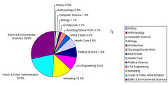
As you can see, we do not have a geography department at the university, so approximately 1/2 of folks needing spatial assistance are either in Earth & Environmental Sciences or Urban & Public Administration. This makes sense as these are the only two departments that confer degrees and certifications in GIS/RS.
It is the other 1/2 that interest me the most. With only a handful of actual credit courses in their major departments, these students are often going out of their way to include maps and spatial analysis in their projects. An ambitious professor who pushes him/herself and their students is always a great motivator.
There are three things that really stand out in my mind from this semester.
- First are all of the marketing students who are taking it on themselves to use spatial datasets and analysis. Once one student found out the great marketing/consumer datasets that we have, these marketing students never stopped coming. Combined, the marketing and real estate students took up almost 18% of my student assistance hours this semester. Let's hear it for the ambitious business students.
(Especially as I get ready to teach the Advanced Real Estate Market Analysis course next semester.) - Second of all was that super-ambitious anthropology student needing to perform a batch viewshed analysis of stone circles in Ireland. This was a lot of fun to assist the student with and it gave GIS a lot of exposure in the anthropology department. The work I did with this student lead to all of the geoprocessing demonstrations and applications I developed this semester.
- Third of all is that the variety of students and question types continue to increase each semester. Political Science students seeking looking to map voting potential. History students seeking to map population and boundary shifts. Add in there epidemiological studies, community assessments for need-based grants, spatial based property valuations...the list really goes on and on.
The Frost and Sullivan report, announced by All Points Blog, project increases in the use and development of location based services. There is no doubt that these students will be the consumers and developers.
Wednesday, December 07, 2005
Canadian Electoral District Maps
The 2004 Federal Electoral District Maps (Canada) are available for free download from Geogratis.
Via: University of Saskatchewan Library: Data Library News Blog
Of course this is part of that great Geogratis site that I wish I knew about when I was working in Buffalo, NY. Anyone needing good national-level spatial datasets for Canada can find loads of good stuff at the Geogratis site.
Check out their Data Archive....
Tuesday, December 06, 2005
Followup: Latest Issue of The Cartographic Journal
This is a follow up from this post.
Turns out that the focus of the December 2005 issue of The Cartographic Journal...
Turns out that the focus of the December 2005 issue of The Cartographic Journal...
"is the special issue from the CUAC/LC conference on the Future of Map Libraries at the Library of Congress in May. It includes all (or essentially all) of the talks given at that conference."
Sent from anonymous poster on Maps-L.
The GIS Feed Community
Keeping current with the latest happenings and events in the GIS world has become very daunting.
The 'GIS Feed Community' is growing very quickly. There are just so many blogs entries, news items, discussions, and technology releases that are really, really interesting and fun stuff that I do not want to miss a moment of them.
So here is an overview of current resources as I understand them. This can serve as an introduction to the somewhat daunting task of keeping up with the GIS feed community, and especially good for folks (like students) first starting to venture out there...
The diagram below represents the sectors of the GIS feed community (Click to Enlarge)
- Aggregators
- Aggregators pull the latest feeds from a variety of sources and display them on one page. They have been very useful in giving the spatial community a central gathering place.
- There are three key aggregators, Planet Geospatial, Journey with GIS, and Planet GIS. Planet Geospatial is especially useful as James Fee does a fantastic job maintaining the aggregator and selecting sites for inclusion, as well as providing access to the XML feed and OPML.
- GIS Editorials
- These are blogs that comment upon, or editorialize on the state of the spatial industry or of particular aspects. They give us the big picture of things.
- Examples include Vector One, EdParsons.com, and think.
- GIS Technology
- These are blogs that focus on GIS technology (in general). They are written/maintained by GIS users and developers and comprise the bulk of the GIS feed community.
- Click here for a list of these GIS Technology blogs.
- Links & Resources
- These are resources that primarily point to and often times compare various resources on the web.
- Key examples include Cartography, The Map Room, and Google Maps Mania.
- Major Software Developer Blogs
- These are blogs maintained by employees of major GIS software developer companies.
- I have no idea whether ESRI is promoting this or not, but ESRI employees have really taken an interest in blogging. The entire list can be viewed here. Chandu Thota's WebLog is a good blog coming from a MapPoint developer.
- Industry News
- There are numerous happenings and releases within the GIS industry these days. It is possible to receive all the important news by using the resources listed above, but if you want to ensure that nothing slips through your grasp you can get your news directly.
- Click here to access a list of industry news feeds.
- Communities
- Communities (user forums) are bulletin boards where you can send/answer questions and discuss GIS topics.
- A list of communities can be found here. Some key communities include SlashGISRS, CartoTalk, comp.infosystems.gis, and comp.soft-sys.gis.esri.
- ListServs with No Feeds
- Unfortunately not all resources currently provide feeds and we are forced to monitor them via email.
- ListServs that I monitor include ESRI-L/ArcView-L, Maps-L, and MapHist.
- Podcasts
- I forgot to include this sector in the image above, but podcasts are downloadable mp3 files that serve as GIS radio shows.
- You must, must, must listen to A VerySpatial Podcast. It is great. Another new podcast whose first episode was very good is Where It's At....
- Directory of GIS Feed Community
- A directory containing these and other categories of available GIS-related feeds can be found here.
- And please oh please do not forget about us librarians. :)
- Other Topics of Interest
- In addition to those mentioned here, other topics of interest for the GIS feed community include: Employment, Scholarly Publications, and Web Mapping.
Saturday, December 03, 2005
Latest Issue of The Cartographic Journal: Maps/GIS & Libraries
The latest issue (December 2005) of the The Cartographic Journal is dedicated entirely to mapping and geospatial issues in libraries. I have not yet been able to get my hands on an issue as our library has not yet received the print copy (any day now...) and our electronic access via Academic Search Premier has not yet updated their content to include this latest issue.
Click here to view the table of contents.
I will post about these articles in more detail once I can actually read them.
Of course, you too can keep up with the latest scholarly GIS publications here.
Click here to view the table of contents.
I will post about these articles in more detail once I can actually read them.
Of course, you too can keep up with the latest scholarly GIS publications here.
Friday, December 02, 2005
GIS Workshops: Spring 2006
I am really, really excited about the workshops we have lined up for next (Spring 2006) semester. Here are the three workshops that we have in mind:
- Murder Mystery (See this earlier post)
- Of course this is a play on the hit TV show Numb3rs.
- I am planning a workshop early March 2006, in which I will lead all workshop participants through an exercise where we use GIS and spatial technologies to track down the cause of a series of fictitious mysterious deaths in Fort Worth.
Here is how I plan to set this up. In mid to late January, I want to announce this event. Announcing the event will involve laying out some basic facts about the fictitious deaths. Then, I want to release more facts and maps of the area pinpointing locations each Wednesday during the month of February. Each week during the month of February, any UTA person may email their solution to the crime. Then, during the first week of March, anyone who has been following the mystery can come to the Library for a hands-on analysis of the fictitious crime details using GIS software to search for patterns using complex mathematical algorithms, thereby solving the crime. The person who solved the crime correctly during the month of February will win something, but of course only if they attend the workshop. (A possible solution that I have been tossing around is following the bus lines, but I do not think I will settle on something so simple.)
I want to release these facts in the campus newspaper various Library publications. I think that I can get the campus newspaper to go along with this, as long as we have an enticing idea, which I believe this to be. - ArcGIS & the Google Maps API
- I plan on holding this in early April 2006. This workshop will be designed for ArcGIS users to learn how to use Google Maps as the front-end for their GIS applications. This is what we did for the Friday Night Hangout project.
- I plan on demonstrating how to download the API and how to export various feature classes into an XML format fit for Google Maps.
- Where to Open a New Pizzeria in the DFW Metroplex?
- This will be held between the Google Maps workshop and the end of the semester.
- This is one of the most popular workshop that I have held and repeat it at least once a year. More than any other, I receive requests from faculty to hold this exercise specifically for their classes. The exercise uses the ArcMap ModelBuilder to provide a form-driven suitability analysis. This is already complete, and you can download the exercise, complete with step-by-step instruction and intro power point here.
Thursday, December 01, 2005
Free Blogging Tools
There are some great free blogging tools out there.
The Geographic Information Systems (GIS) GeoBlog inspired me and I have added the following resources to my blog:(These tools can be found on the bottom right-side of my blog)
I also discovered, for those of you hosting your blog on Blogspot (like me), a free TrackBack pinger: Trackback wizard. I have not tried HaloScan yet, but I hear this free resource can give Blogger blogs the ability to store TrackBacks.
Subscribe to:
Posts (Atom)
