- You need to turn left in 2500 feet
- Your bank is on the right-hand corner, account balance of $4.35 (ouch...)
- 1.4 miles west, along Main Street, is the location of the blog: mapz: a gis librarian
- You just passed the Chinese restaurant that gave you the runs last Tuesday
- "Please be careful Michael. Current news headlines indicate a recent series of muggings in this neighborhood."
- Just passed the residence of ObiWan123, member of the following Frappr Maps: GIS Librarians & VerySpatial
- You are quick approaching the geotagged photos (adult) of MissKittie69. Click here to view.
Remember the news reports of that French guy who crashed his car because he followed his GPS instructions? In this story, the GPS unit was directing the French guy to a hotel and instructed him to make an immediate u-turn. This is a classic case of how spatial technologies enabled virtual information (street network, GPS coordinates, and hotel locations) to direct the actions here in the real world. How far away are we from giving navigation devices actual driving privileges? Not very far at all.
Let's take a look at the state of things. More and more virtual materials are being given geotags, which enables these virtuals to be geospatially located. More and more of these geotagged items are being made available via public web services and/or public feeds. Spatial mashups integrating various services/feeds are not a passing fad. Google Earth is set to be integrated with Honda and VW.
This deserves its own paragraph. Google Earth is set to be integrated with Honda and VW. Imagine importing Declan Butler's Google Earth Avian Flu KML file. ArcMap scripts can export to KML, as can MapInfo, and Shape2Earth can convert shapefiles to KML without an additional GIS application. Just think of the various geotagged virtuals that can be uploaded/accessed via your in-car navigation system.
I can think of no medium or technology that will tear down the boundaries between the virtual and the real more succinctly than geospatial technologies. We are all heading toward a society where geospatially-driven augmented reality will become commonplace. I not only foresee, but I yearn for the day when portable augmented reality systems will allow me to spatially see and interact with geotagged virtual items.
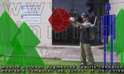
Here are some images from Tinmith Augmented Reality Research to give you more of an idea of what augmented reality is.


As I was writing this, however, something that I initially could not put my finger on was bothering me. Something was missing. Now I think I have figured it out. (Isn't it great how writing does this for us?) There is a growing trend to geotag popular and daily consumer items, such as blogs, photos, friends, clubs, even news stories. However, I feel there is a lack of geotagged scholarly resources. Resources such as scholarly journal articles (there are a number of fantastic open source journals out there). Tags can be generated for the author location and more importantly for different geospatial subjects or locations of interest in the article. Scholarly books as well. I want to ensure that when the walls between the virtual and the real come fumbling down, there is a place for the scholarly as well as the popular.

No comments:
Post a Comment